 |
| |
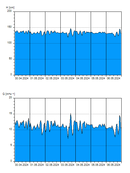
H
[cm]
|
Q
[m3.s-1]
|
QN
|
|
13.06.2026 05:40
| 133 |
11,34
|
|
|
13.06.2026 05:20
| 132 |
11,06
|
|
|
13.06.2026 05:00
| 131 |
10,78
|
|
|
13.06.2026 04:00
| 131 |
10,78
|
|
|
13.06.2026 03:00
| 133 |
11,34
|
|
|
13.06.2026 01:00
| 143 |
14,48
|
|
|
13.06.2026 00:00
| 141 |
13,76
|
|
|
12.06.2026 23:00
| 133 |
11,34
|
|
|
12.06.2026 22:00
| 128 |
9,920
|
|
|
12.06.2026 21:00
| 134 |
11,62
|
|
|
12.06.2026 20:00
| 134 |
11,62
|
|
|
12.06.2026 18:00
| 130 |
10,50
|
|
|
12.06.2026 17:00
| 137 |
12,50
|
|
|
12.06.2026 16:00
| 137 |
12,50
|
|
|
12.06.2026 15:00
| 135 |
11,90
|
|
|
12.06.2026 14:00
| 136 |
12,20
|
|
|
12.06.2026 13:00
| 141 |
13,76
|
|
|
12.06.2026 12:00
| 130 |
10,50
|
|
|
12.06.2026 11:00
| 142 |
14,12
|
|
|
12.06.2026 10:00
| 133 |
11,34
|
|
|
12.06.2026 09:00
| 138 |
12,80
|
|
|
12.06.2026 08:00
| 140 |
13,40
|
|
|
12.06.2026 07:00
| 139 |
13,10
|
|
|
11.06.2026 07:00
| 125 |
9,050
|
|
|
10.06.2026 07:00
| 115 |
6,400
|
|
|
09.06.2026 07:00
| 123 |
8,498
|
|
|
08.06.2026 07:00
| 116 |
6,654
|
|
|
07.06.2026 07:00
| 130 |
10,50
|
|
H — water level
Q — Discharge
QN — QN |