 |
| |
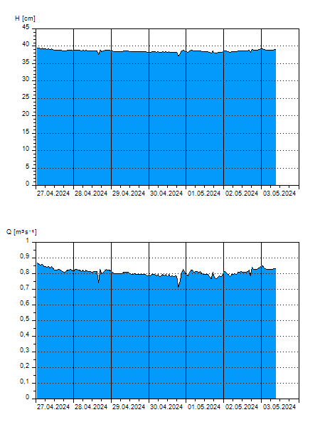
H
[cm]
|
Q
[m3.s-1]
|
QN
|
|
13.06.2026 06:00
| 38 |
0,694
|
|
|
13.06.2026 05:00
| 37 |
0,626
|
|
|
13.06.2026 04:00
| 36 |
0,606
|
|
|
13.06.2026 03:00
| 36 |
0,572
|
|
|
13.06.2026 02:00
| 36 |
0,565
|
|
|
13.06.2026 01:00
| 36 |
0,552
|
|
|
13.06.2026 00:00
| 35 |
0,538
|
|
|
12.06.2026 23:00
| 35 |
0,511
|
|
|
12.06.2026 22:00
| 35 |
0,502
|
|
|
12.06.2026 21:00
| 35 |
0,502
|
|
|
12.06.2026 20:00
| 35 |
0,511
|
|
|
12.06.2026 19:00
| 35 |
0,507
|
|
|
12.06.2026 18:00
| 35 |
0,507
|
|
|
12.06.2026 17:00
| 35 |
0,502
|
|
|
12.06.2026 16:00
| 35 |
0,502
|
|
|
12.06.2026 15:00
| 35 |
0,502
|
|
|
12.06.2026 14:00
| 35 |
0,507
|
|
|
12.06.2026 13:00
| 35 |
0,518
|
|
|
12.06.2026 12:00
| 35 |
0,531
|
|
|
12.06.2026 11:00
| 36 |
0,558
|
|
|
12.06.2026 10:00
| 36 |
0,565
|
|
|
12.06.2026 09:00
| 36 |
0,586
|
|
|
12.06.2026 08:00
| 36 |
0,586
|
|
|
12.06.2026 07:00
| 37 |
0,619
|
|
|
11.06.2026 07:00
| 37 |
0,640
|
|
|
10.06.2026 07:00
| 34 |
0,463
|
|
|
09.06.2026 07:00
| 31 |
0,348
|
|
|
08.06.2026 07:00
| 32 |
0,388
|
|
|
07.06.2026 07:00
| 32 |
0,397
|
|
H — water level
Q — Discharge
QN — QN |