 |
| |
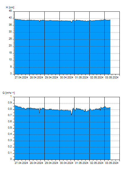
H
[cm]
|
Q
[m3.s-1]
|
QN
|
|
17.03.2026 18:00
| 42 |
0,979
|
|
|
17.03.2026 17:00
| 42 |
1,017
|
|
|
17.03.2026 16:00
| 42 |
0,972
|
|
|
17.03.2026 15:00
| 42 |
0,979
|
|
|
17.03.2026 14:00
| 42 |
0,994
|
|
|
17.03.2026 13:00
| 42 |
1,002
|
|
|
17.03.2026 12:00
| 42 |
1,010
|
|
|
17.03.2026 11:00
| 42 |
1,010
|
|
|
17.03.2026 10:00
| 42 |
1,025
|
|
|
17.03.2026 09:00
| 43 |
1,040
|
|
|
17.03.2026 08:00
| 43 |
1,040
|
|
|
17.03.2026 07:00
| 43 |
1,040
|
|
|
17.03.2026 06:00
| 43 |
1,040
|
|
|
17.03.2026 05:00
| 43 |
1,048
|
|
|
17.03.2026 04:00
| 43 |
1,055
|
|
|
17.03.2026 03:00
| 43 |
1,078
|
|
|
17.03.2026 02:00
| 43 |
1,108
|
|
|
17.03.2026 01:00
| 44 |
1,154
|
|
|
17.03.2026 00:00
| 44 |
1,124
|
|
|
16.03.2026 23:00
| 43 |
1,055
|
|
|
16.03.2026 22:00
| 43 |
1,070
|
|
|
16.03.2026 21:00
| 43 |
1,101
|
|
|
16.03.2026 20:00
| 44 |
1,124
|
|
|
16.03.2026 19:00
| 44 |
1,139
|
|
|
16.03.2026 07:00
| 43 |
1,063
|
|
|
15.03.2026 07:00
| 43 |
1,086
|
|
|
14.03.2026 07:00
| 44 |
1,139
|
|
|
13.03.2026 07:00
| 44 |
1,169
|
|
|
12.03.2026 07:00
| 45 |
1,207
|
|
|
11.03.2026 07:00
| 46 |
1,274
|
|
H — water level
Q — Discharge
QN — QN |